| |
Information on Torrox |
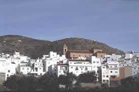
An Andalucian village
combines with modern beach life facilities |
 |
| |
|
Surface Area: |
50 square kilometres |
Population: |
about 17,000 |
What the natives are called: |
Torroxeños. Nickname: Hocicones |
| Monuments: |
the Roman complex of El Faro de
Torrox (Roman villa, bathhouses, necropolis, etc.),
the Nuestra Señora de la Encarnación
parish church, the Nuestra Señora de las
Nieves hermitage and convent, San Roque church,
Casa de la Moneda (Mint)
|
| Geographical Location: |
in the southern part of the region
of La Axarquía, at the foot of the Tejeda
and Almijara mountain ranges. The village is 145
metres above sea level and is 40 kilometres from
the city of Málaga and 20 from Vélez
Málaga. Average precipitation within the
municipality is 530 litres per square metre and
the average annual temperature is 19º C.
|
Tourist Information: |
Town Hall, Plaza de la Constitución,
1. Telephone: 952 538 200;
|
| |
|
|
This municipality’s terrain is so
rugged that it seems to positively abhor
level land, being an endless succession
of ravines and hills. Due to their proximity
to the sea, the hills do not rise to great
altitudes. Their highest points such as
La Rábita de Torrox and the Cocoja,
which abound in low brush, are not more
than 700 metres high.
The Torrox stream, which the villagers
also call Patalamara, La Plata or Argentino,
crosses the municipality from north to south
and its waters are used to the full for
irrigation before they empty into the sea
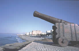
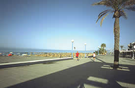
at Punta de Torrox. The municipality has
nine kilometres of sandy beaches along which
lie the population centres of Torrox Costa
and El Morche.
|
|
 |
© Costa del
Sol Tourist Board |
|
|
| This
municipality is an eminently agricultural
landscape, but due to the extremely
uneven terrain, there has been no
alternative but to terrace the hills
to make use of the land and make it
cultivable. Thus, terraces are the
most noticeable feature of an area
where subtropical fruits have found
a perfect home.
A polished axe from the Neolithic
period has been found at the hamlet
of Los Casarones, some two kilometres
north of the village, proving that
there were already human settlements
in this area at that time. It probably
was also colonised by Punics or Phoenicians,
considering the proximity of the Trayamar
and Mezquitilla archaeological sites
in Algarrobo Costa. This continues
to be just a hypothesis, however,
since so far no remains have been
found to prove it.
There is no room for doubt, however,
of the strong Roman presence in the
area known as Faro or Punta de Torero.
Substantial remains have been found
there of the city of Caviclum, which
was founded in the first century and
remained active at least until the
eighth century. It was around the
middle of that century that Omeya
Abderramán established himself
in Torrox after landing at Almuñécar,
and he would shortly afterwards establish
the independent Caliphate of Córdoba. |
|
 |
© Tourist
Board Costa del Sol |
|
|
 |
© Tourist
Board Costa del Sol |
|
|
Some historians
identify Torrox as Hisn Turrus, where in
the year 914 troops under Abderramán
III defeated those of Omar Ibn Hafsun, the
Muladí rebel who had set out to topple
the Caliphate of Córdoba. After this
event, Torrox came under the jurisdiction
of Frigiliana. It is known that throughout
the long Muslim domination the village was
an important silk producer, which is why
its irrigated lowlands were devoted to raising
mulberry trees.
The fall of Vélez to the Christian
troops in 1487 had such an effect on the
region that many other localities surrendered
without a fight in order to prevent greater
problems.
|
|
Torrox did so on 29 April 1487,
just two days after the taking of Vélez.
Very shortly afterwards, however, the chieftain
El Zagal recaptured the village for the Muslims,
in whose hands it would remain only a few months
before passing again into the control of the Christian.
|
|
When the Morisco rebellion
broke out in 1568, half the population
was made up of Old Christians and
the other half of Moriscos. Many of
the latter took part in the El Peñón
de Frigiliana insurrection. By the
year 1571 at least 22 Moriscos from
Torrox had been prosecuted by the
Tribunal del Santo Oficio (Holy Office
Tribunal) of Granada. It is documented
that the members of the Quilat family
were burned at the stake, accused
of professing the Mohammedan religion.
The significant participation by the
Moriscos of this area in the uprising
resulted in stern repression that
caused the abandonment of the eight
Arabic settlements that made up the
municipal territory: Alhandiga, Almeida,
Arcos Benamayor, Cajauja, Lautín,
Lugarejo and Periana (a different
locality from the modern one).
|
|
 |
© Costa del Sol Tourist
Board |
|
|
 |
©
Costa del Sol Tourist Board |
|
|
During the
eighteenth century the local economy was
based on sugar cane production, to which
more than 80 per cent of the arable land
in the municipality was devoted, and there
were two sugar mills. The El Faro de Torrox
ruins were discovered in 1773, at which
time the municipal population was about
3,000.
Torrox entered the nineteenth century with
an epidemic of yellow fever in 1804 that
decimated the population. A few years later
it suffered the occupation by the Napoleonic
troops, who in 1812 “bade farewell”
to the village by blowing up the castle.
Nevertheless, the municipality was experiencing
unusual prosperity in the middle of the
century. At that time it had two olive oil
mills, two potteries, three flour mills,
a brandy distillery and the sugar mill that
belonged to the Larios family.
|
|
|
|
| |
|